Bentley Systems Partners with Google to Bring Powerful Geospatial Context and Capabilities to Infrastructure

Collaboration enables use of Google 2D, 3D geospatial content within Bentley’s applications and platforms to deliver actionable insights to infrastructure professionals

VANCOUVER (Bentley Systems’ Year in Infrastructure 2024) — Bentley Systems, Incorporated (Nasdaq: BSY), the infrastructure engineering software company, today announced a strategic partnership with Google to integrate Google’s high-quality geospatial content with Bentley’s infrastructure engineering software and digital twin platform to improve the way infrastructure is designed, built, and operated.

As a digital representation of the physical world, digital twins unlock meaningful value and insights throughout the infrastructure lifecycle, from project planning and design through construction and asset operation. By leveraging the engineering data created and managed in Bentley software alongside Google’s geospatial data, AI and analytics, and cloud technologies, engineers can design and manage infrastructure in context and at scale to address today’s most urgent challenges, from mitigating climate risk to maintaining aging infrastructure.

Through the partnership, Bentley software users and developers can use Google Maps Platform’s geospatial content, including Google’s stunning Photorealistic 3D Tiles, for real-world geospatial context and immersive 3D experiences in their digital workflows. The partnership complements Bentley’s recent acquisition of Cesium, the foundational open platform for creating powerful 3D geospatial applications. Cesium is the creator of the 3D Tiles open standard used by Google. Bentley is also collaborating with Google Cloud to deliver AI-driven insights for asset analytics.

Bentley CEO Nicholas Cumins said, “By combining Google’s extensive geospatial content and cloud capabilities with Bentley’s infrastructure engineering software and digital twin platform, infrastructure professionals can improve their work and ensure projects and assets are created and operated with greater resilience and sustainability. This partnership demonstrates how open standards, such as 3D Tiles, can help infrastructure professionals evolve their practices by leveraging the power of geospatial context.”

Chris Phillips, vice president and general manager of Geo at Google, commented, “Photorealistic 3D Tiles in Google Maps Platform power breathtaking immersive experiences and can transform workflows for architects, engineers, and urban planners. We’re excited to partner with Bentley to bring powerful geospatial context and capabilities that can dramatically improve how infrastructure is designed, built, and operated with data.”

Google 3D tiles of Vancouver, enabled through Cesium technology, that will be available within iTwin. (Photo: Bentley Systems)

For more information, contact:
Press: Chris Phillips, PR@news.bentley.com
Investors: Eric Boyer, IR@bentley.com

About Bentley Systems
Bentley Systems (Nasdaq: BSY) is the infrastructure engineering software company. We provide innovative software to advance the world’s infrastructure – sustaining both the global economy and environment. Our industry-leading software solutions are used by professionals, and organizations of every size, for the design, construction, and operations of roads and bridges, rail and transit, water and wastewater, public works and utilities, buildings and campuses, mining, and industrial facilities. Our offerings, powered by the iTwin Platform for infrastructure digital twins, include MicroStation and Bentley Open applications for modeling and simulation, Seequent’s software for geoprofessionals, and Bentley Infrastructure Cloud encompassing ProjectWise for project delivery, SYNCHRO for construction management, and AssetWise for asset operations. Bentley Systems’ 5,000 colleagues generate annual revenues of more than $1 billion in 194 countries.
www.bentley.com

© 2023 Bentley Systems, Incorporated. Bentley, the Bentley logo, Bentley Infrastructure Cloud, Bentley Open, AssetWise, iTwin, MicroStation, ProjectWise, Seequent, and SYNCHRO are either registered or unregistered trademarks or service marks of Bentley Systems, Incorporated or one of its direct or indirect wholly owned subsidiaries. All other brands and product names are trademarks of their respective owners.

- Video Advertisement -

Related Post

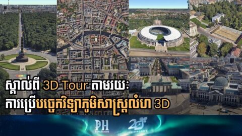
Bentley Launches Berlin 3D Tour Ahead of Tech Summit

Bentley Systems has launched a highly detailed, Cesium-powered 3D tour of Berlin in anticipation of its largest-ever in-person technical learning event, the Bentley Tech Summit 2025, set to take place in the German capital from December 9-11. The interactive, city-scale visualization invites users to explore Berlin’s iconic landmarks, celebrating the city’s history of engineering resilience […]

Clicking a Button to Fight Climate Change: Bentley’s 3D Geospatial Tech Goes to COP30

What if we could inspect a remote wildfire, survey a flood zone, or model a massive urban project from a desktop? According to global engineering software leader Bentley Systems, this is no longer a hypothetical question—it’s the new front line in the fight against climate change. As the city of Belém prepares to host the […]

Digital Reality Check: How 3D Geospatial Tech is Minimizing Costly Mistakes in Global Construction

In the high-stakes world of construction, where a single wrong decision can cost millions, infrastructure developers are increasingly turning to 3D geospatial technology to test and visualize their choices before breaking ground. Bentley Systems, the infrastructure engineering software giant, is spearheading this shift by integrating the advanced capabilities of its recent acquisition, Cesium, into the […]

Bentley Systems Unveils New AI, Geospatial, and Cloud Tools to Transform Infrastructure Engineering

What’s new in Bentley Systems’ Year in Infrastructure 2025? Bentley Systems, a leading infrastructure engineering software company, announced a major expansion of its digital portfolio at its Year in Infrastructure 2025 conference, held on October 15 and 16 in Amsterdam. The company unveiled new Artificial Intelligence (AI) applications, deepened the integration of geospatial modeling through […]

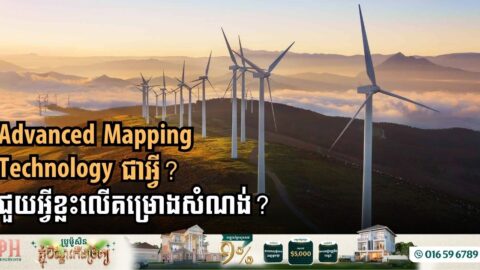
How Advanced Mapping is Revolutionizing the Energy Future

The energy sector is undergoing a massive transformation, driven by the adoption of advanced geospatial technologies that are making a “digital-by-default” approach essential for large-scale energy infrastructure programs. These precision mapping solutions are fundamentally changing how energy assets—from oil and gas to renewables like solar and wind—are planned, constructed, and maintained, promising greater efficiency, accuracy, […]

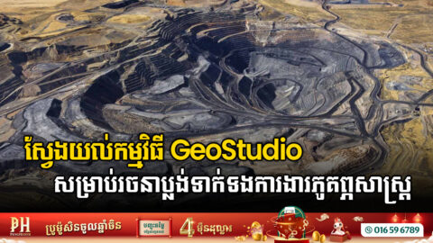
GeoStudio, the Future of Limit Equilibrium Analysis

By Louis Henry Prates Integrated geotechnical workflow Seequent’s vision is to provide a suite of underground solutions that seamlessly integrate into every stage of infrastructure development. Starting with field data collection and management with OpenGround, moving on to subsurface characterization and geological modeling with LeapFrog Works, and culminating in advanced Geotechnical Analysis with PLAXIS and […]