Digital Twin Technology Paves the Way for Cambodia’s New PP-Bavet Expressway
 webmaster@construction-property.com
- 1 October 2025
- Uncategorized
- 2077 Views
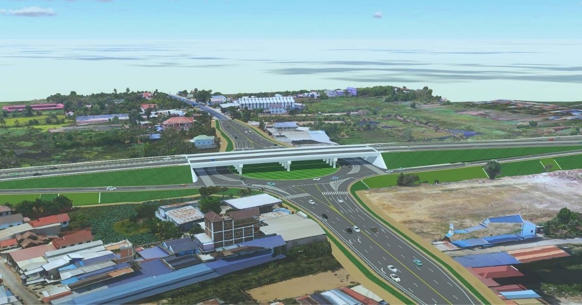
The construction of Cambodia’s second major expressway, the 138-kilometer Phnom Penh-Bavet Expressway, is leveraging cutting-edge digital twin technology from Bentley to overcome significant geographical and cultural hurdles.
The project, implemented by the aims to enhance Cambodia’s logistic connectivity with Vietnam. The expressway starts from the Third Ring Road in Phnom Penh and ends in Bavet City.
During the design and planning stage, CRBC faced several complex challenges. First, the initial 33 kilometers of the project lie within a floodplain where heavy seasonal rains can cause the Mekong River to overflow, creating water depths of up to six meters for up to six months. Second, the proposed route could affect a large number of existing temples and cultural relics that cannot be moved. Lastly, the first section of the project passes through a heavy traffic area of Phnom Penh city with numerous houses, which makes the required relocation more complicated.
To solve these problems, CRBC turned to Bentley’s software, which helped the company lower earthworks by two million cubic meters, improve modeling efficiency, reduce modeling time by 50%, and shorten the design cycle by 20%.
To begin, CRBC used Bentley ProjectWise and iTwin to create a digital resource management platform and a connected data environment, ensuring all project information was always current and accessible to every stakeholder.
The team then built a model of the project site using Bentley iTwin Capture, which helped them visualize and better lay out the expressway route. This 3D virtual environment allowed participants to “quickly find out the design problems, such as the road encroaching on temples,” and provide timely feedback.
Bentley MicroStation, OpenRoads, and OpenBridge, along with interoperable third-party applications, the team successfully created a digital twin of the highway and its facilities.
The OpenRoads application was critical for testing traffic simulations for future years to identify potential congestion areas and design effective intersections. Furthermore, the analysis within the application helped them design the road to be 0.5 meters above the maximum flood level.
By working collaboratively on a single 3D digital twin, all teams and specialists were able to boost design efficiency and road quality.
Using photographic site data in the digital twin helped the team identify land acquisition boundaries. This approach reduced the adverse impact on surrounding communities by minimizing disruption to temples, schools, houses, historical sites, graves, and other facilities, while also improving communication with local residents regarding demolition.
The digital twin was used to optimize vertical alignment and reduce the fill height, leading to a reduction in earthworks by two million cubic meters and eliminating 142,860 kilometers of truck travel.
Creating a parameterized cross-section template in OpenRoads allowed CRBC to efficiently test variables and solutions, improving modeling efficiency and reducing modeling time by 50%.
A deeper understanding of the project site via the digital twin allowed the team to change part of a bridge in the flood zone into a partial subgrade road, which saved a significant amount of money and eliminated the need for 16,000 tons of concrete.
- Video Advertisement -
 English
  ខ្មែរ
ខ្មែរ