Exploring Dutch water infrastructure masterpiece through Cesium 3D geospatial technology

The Netherlands is famous for its extremely low altitude, with a significant portion of the country lying below sea level. This paradox of living below water is only possible due to one of the world’s most extensive and sophisticated water management infrastructures.

Approximately one-third of the Netherlands is below sea level, and about two-thirds of the country is vulnerable to flooding from the sea or rivers. The lowest is the Zuidplaspolder, at approximately −6.76 meters (22 feet) below sea level.

Meanwhile, the country’s capital, Amsterdam, and the surrounding area, including Schiphol Airport, are built on reclaimed land called polders and lie below sea level. Schiphol Airport is notoriously situated around −4 meters (13 feet) below sea level.

Why Amsterdam Doesn’t Flood: The Special Infrastructure

The Netherlands, and Amsterdam in particular, do not flood because of a centuries-old, complex, and constantly upgraded system known as the “Delta Works” and a layered flood defense strategy:

1. Dikes and Dams (Prevention): The primary defense is an immense network of natural coastal dunes and man-made dikes and levees that wall off the sea and rivers. The country has roughly 22,000 kilometers of dikes. Additionally, massive, movable engineering marvels, such as the Oosterscheldekering (Eastern Scheldt storm surge barrier) and the Maeslantkering, can be closed during severe storms to protect vast inland areas from North Sea surges.

2. Polders and Water Management (Control): The land below sea level is sectioned into polders (reclaimed land areas). Within these polders, water levels are actively controlled. Moreover, a complex system of canals, drainage ditches, and sluices also collects and channels excess water. Lastly, powerful pumping stations (historically, windmills) work continuously to pump water out of the low-lying polders and into higher-level canals and lakes (the boezem system), from where it can eventually be released into the sea at low tide. This keeps the low-lying areas dry.

3. Room for the River (Adaptation): Recognizing the risk of river flooding, the modern strategy involves “giving the water space.” Projects involve moving dikes further inland, creating high-water channels, and deepening river beds to increase the river’s capacity to safely carry water to the sea, rather than solely fighting it with higher dikes.

In short, the Netherlands maintains its dry land through a sophisticated, multi-layered system that not only prevents the sea from getting in (dikes/barriers) but also actively removes water that falls or seeps in (polders and pumps). This continuous, highly regulated water management is what makes the country habitable below sea level.

No wonder Bentley Systems, the global infrastructure engineering software company, chose Amsterdam to host its annual Year in Infrastructure and Going Digital Awards (YII), an event many in the industry consider the “Oscars of infrastructure.”

Starting Oct. 15, Bentley’s Year in Infrastructure will bring together global industry leaders to showcase excellence in infrastructure delivery and digital innovation. The two-day event features expert sessions, keynote speakers, and the prestigious Going Digital Awards, celebrating visionary projects in engineering, design, construction, and operations. To whet your appetite, we’ve built an interactive experience of the country’s infrastructure and main sights using Cesium 3D geospatial technology.

YII 2025 – Amsterdam | Cesium Stories

- Video Advertisement -

Related Post

How Data-Driven Workflows Are Changing Engineering Delivery

For decades, the engineering and construction industry has relied on the exchange of digital files—the familiar DWGs and PDFs—as the bedrock of project delivery. However, as global infrastructure grows in complexity, a new paradigm is emerging. Experts are calling for an evolutionary crossroads where the industry moves beyond static file handovers toward dynamic, data-driven workflows. […]

Bentley Digital Twin Drives AU$105 Million in Savings for Melbourne’s M80 Ring Road

ACCIONA is setting a new global benchmark for “going digital” in infrastructure, leveraging Bentley Systems’ comprehensive software suite to manage the AU$ 3.8 billion M80 Ring Road Completion project. By deploying a sophisticated digital twin strategy, the project team has successfully slashed planning times and is on track to mitigate over AU$ 105 million in […]

Indonesia Leverages Bentley Software to Build World’s Largest Refuse-Derived Fuel Plant

PT Wijaya Karya (WIKA) has recently completed construction for the Rorotan Jakarta Refuse-Derived Fuel (RDF) Plant, a monumental project set to become the world’s largest facility of its kind. The IDR 1.28 trillion facility is designed to process 2,500 tons of municipal waste daily, converting it into 875 tons of sustainable fuel. To manage a […]

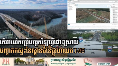
Digital Twin Tech Breaks Decades-Old Deadlock on Major I-95 Bridge Project

Engineering firm Johnson, Mirmiran & Thompson (JMT) has successfully utilized high-tech 3D modeling and connected data known as digital twin to solve congestion on I-95 crossing over the Rappahannock River in eastern Virginia, in the United States. For decades, the I-95 crossing over the Rappahannock River was defined by chronic congestion and a “not-in-my-backyard” stalemate. […]

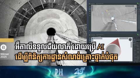
AI-Powered Digital Twin Revolutionizes Tunnel Maintenance in Italy

Italferr S.p.A. has set a new benchmark in railway safety by implementing an AI-powered digital twin for the Serravalle Tunnel, part of the strategic Tezo Valico dei Giovi line connecting Genoa and Milan. By moving away from manual, time-consuming inspections, the project has successfully automated defect detection, dramatically reducing operational risks. The primary challenge for […]

Saudi Arabia Sets Global Smart City Benchmark with “Manarah” Urban Data Platform

The Al Madinah Region Development Authority (MDA) has successfully launched the Manarah Urban Data Platform (MUDP), a state-of-the-art digital twin initiative that balances the rapid expansion goals of Saudi Vision 2030 with the preservation of ancient Islamic heritage. By utilizing a specialized suite of Bentley Systems software, the MDA has mapped 55 square kilometers of […]