Cambodia Advances Geospatial Infrastructure with Major Progress in National Satellite Network

Landmark CORS project hits key milestones in station construction to revolutionize land registration, smart city planning, and scientific research

Cambodia is taking a significant leap forward in modernizing its national geospatial infrastructure as the development of the Continuously Operating Reference Stations (CORS) satellite network project marks substantial progress. As of May 31, 2026, the dedicated project team has successfully maintained momentum in constructing and expanding this critical network across the country according to plan. Recent construction activities have focused on mobilizing technical sites, removing concrete molds, curing concrete structures, and setting up structural frameworks for the permanent stations. Simultaneously, engineers have been digging specialized trenches to lay underground cables for electrical wiring, installing advanced lightning protection systems, and setting up main cabinets to ensure operational resilience.

This technical undertaking has achieved remarkable numbers in its strategic rollout. Overall, the project has finalized the construction of concrete pillars at 66 reference stations nationwide. Furthermore, 37 of these locations have successfully completed the full installation of electrical wiring, protective lightning systems, and main control cabinets. This steady deployment represents a foundational shift in how the nation will manage its physical space, moving closer to a completely integrated digital mapping system.

The primary objective of this expansive satellite-based project is to accelerate the speed and accuracy of cadastral surveying while strengthening public administrative services connected to land registration. By implementing a permanent and highly accurate satellite measurement network, Cambodia aims to drastically improve land titling efficiency and elevate overall infrastructure planning. Beyond land registry, these stations are designed to support a wide array of vital national developments. The geospatial data generated will serve as the backbone for creating comprehensive base maps, developing physical infrastructure, enforcing strict construction quality controls, expanding communication networks, and guiding the future architecture of smart cities.

Technically known as the CORS network, this infrastructure functions as a national geodetic network measured through constant satellite synchronization. Each station continuously receives high-precision signals from the Global Navigation Satellite System (GNSS), allowing for real-time data collection. The streams of information provided by this system are vital not only for daily surveying and precise geographic positioning but also for advanced scientific endeavors, including monitoring the subtle movements of tectonic plates and supporting other earth science research. (Read More) (Read More)

- Video Advertisement -

Related Post

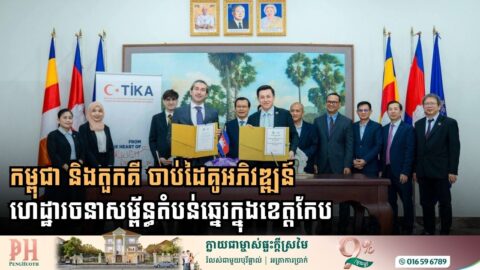
Cambodia and Turkey Partner to Transform Coastal Infrastructure in Kep Province

New Memorandum of Cooperation paves the way for a 1200-meter concrete road to boost the economy and eco-tourism in the Angkol fishing community On May 14, 2026, the Ministry of Land Management, Urban Planning and Construction of Cambodia officially entered into a Memorandum of Cooperation with the Turkish Cooperation and Coordination Agency, widely known as […]

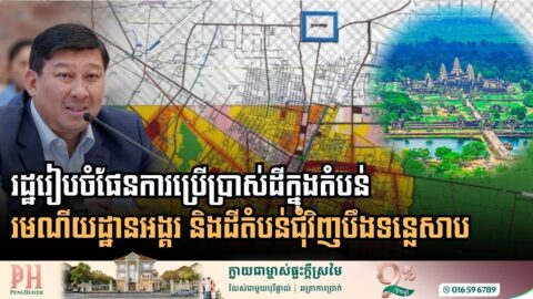
Siem Reap Province Unveils Comprehensive Land Use Master Plan to Preserve Angkor Heritage and Tonle Sap Lake

In a significant move towards sustainable development, the Royal Government of Cambodia has initiated a comprehensive review of land use conditions and master plans across Siem Reap Province. The focus is prominently on the iconic Angkor site and the surrounding areas of Tonle Sap Lake. This decision was highlighted during a recent meeting held by […]

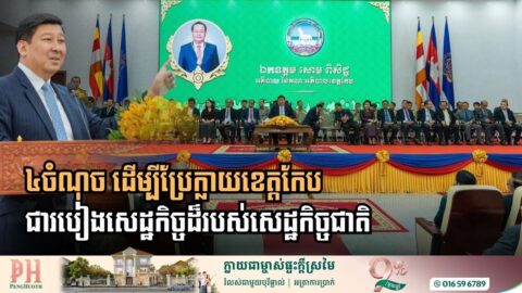
Strengthening Kep’s Foundations: A Strategic Roadmap to a National Economic Corridor

Deputy Prime Minister Say Samal outlines four priority areas to elevate Kep’s status through enhanced security, infrastructure expansion, and human resource development The Royal Government of Cambodia has officially launched a strategic initiative to transform Kep province into a formidable pillar of the national economy. During a high-level review of the 2025 achievements and the […]

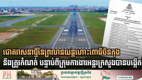
Government Commissions Specialized Task Force to Redefine Future of Old Phnom Penh International Airport

Inter-ministerial group led by Secretary of State Chheang Vannarith to study long-term management and public utility of the historic Pochentong site as commercial aviation shifts to Techo International Airport The Royal Government of Cambodia has officially established a high-level inter-ministerial task force to conduct a comprehensive study on the management and future utilization of the […]