


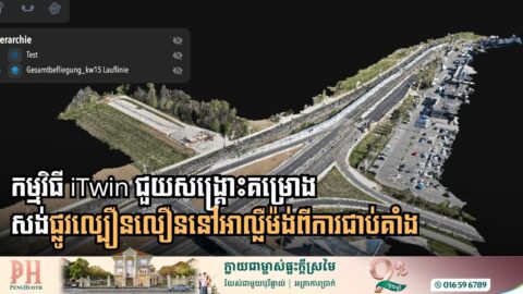
Tech Pivot Saves Germany’s First All-Digital Highway Project
A landmark infrastructure project in Germany is back on track and shattering efficiency records after a critical mid-course correction in its digital strategy. Viscan GmbH, the company tasked with creating a “digital twin” for the B29 highway expansion in Baden-Württemberg, successfully rescued the project from technical failure by overhauling its data processing systems. The ambitious […]

How Data-Driven Workflows Are Changing Engineering Delivery
For decades, the engineering and construction industry has relied on the exchange of digital files—the familiar DWGs and PDFs—as the bedrock of project delivery. However, as global infrastructure grows in complexity, a new paradigm is emerging. Experts are calling for an evolutionary crossroads where the industry moves beyond static file handovers toward dynamic, data-driven workflows. […]

Bentley Systems Breaks Bottlenecks with New iTwin Capture Workflow
Bentley Systems is redefining the digital twin landscape by launching a more flexible, scalable approach to reality modeling. The new iTwin Capture workflow aims to eliminate the traditional “hardware wall” and high upfront costs that have long hindered engineers and urban planners. For years, infrastructure professionals have struggled with massive datasets—from LiDAR point clouds to […]

Digital Twins and IoT Spark a New Era in Mining Intelligence
According to a new industry report from Bentley Systems, 88% of mining organizations now recognize digital twins as high-impact technology, with nearly 90% already implementing or planning projects. For decades, mining data has been trapped in silos—split between geological reports, manual inspections, and disconnected sensors. The industry is now pivoting toward “Evergreen Digital Twins,” virtual […]

Europe’s Aging Power Grid Faces Digital “Makeover” to Meet 2030 Climate Goals
With many distribution grids expected to exceed their 40-year lifespan by 2030, EU policymakers and industry leaders are pivoting toward a “digital-first” strategy to prevent the system from buckling under the pressure of the green transition. The EU electricity infrastructure currently spans over a million kilometers, serving 600 million customers. To meet climate targets, the […]

Innovative Digital Twin Model Set to Revolutionize Public Transport in Greater Cairo
To modernize its aging infrastructure, the Greater Cairo Region (GCR) is leveraging Bentley Systems’ digital tools to develop a new predictive multimodal transportation model. Implemented by CitiME, the project utilizes Bentley OpenPaths™ CUBE™ to establish a “robust digital foundation” for mobility analytics. This software enables planners to integrate multimodal data, mapping complex travel patterns across […]