 English
  ខ្មែរ
ខ្មែរ 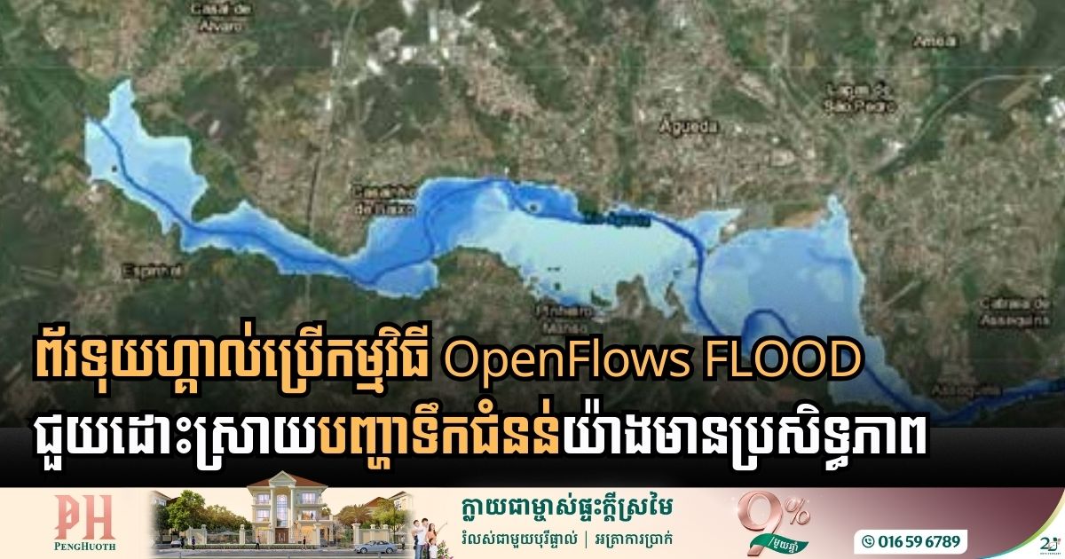

Sabesp Transforms Water Infrastructure Through Digital Twin Technology
- 25 July 2026
Sabesp, one of the world’s largest water and waste management companies, is revolutionizing how it serves 30 million residents in São Paulo, Brazil, by shifting from reactive, manual processes to a proactive, data-driven framework called INTEGRA 4.0. To achieve universal water and sanitation access, the utility partnered with Bentley Systems to break down data silos […]
Bentley Introduces New OpenFlows 2026 to Modernize Water Infrastructure Modeling
- 17 June 2026
Bentley Systems has officially introduced OpenFlows 2026, a significant update designed to help engineers analyze and design water, sewer, and storm networks with greater speed and efficiency. By integrating advanced digital tools, the software aims to eliminate common workflow bottlenecks and foster better cross-disciplinary collaboration. A standout addition is the introduction of Bentley Copilot, an […]

Digital Twins: The New Shield Against El Niño’s Cascading Grid Threats
- 24 May 2026
To combat the super El Niño looms for 2026, utility companies are now shifting away from traditional reactive repairs and toward proactive, data-driven resilience using Bentley Systems’ software. In 2025, utility companies are facing a dangerous new reality where weather disasters no longer happen in isolation. Modern power grids are increasingly vulnerable to cascading failures—where […]
Bentley Systems Bridges the Gap in Water Management with Digital Twin Technology
- 10 May 2026
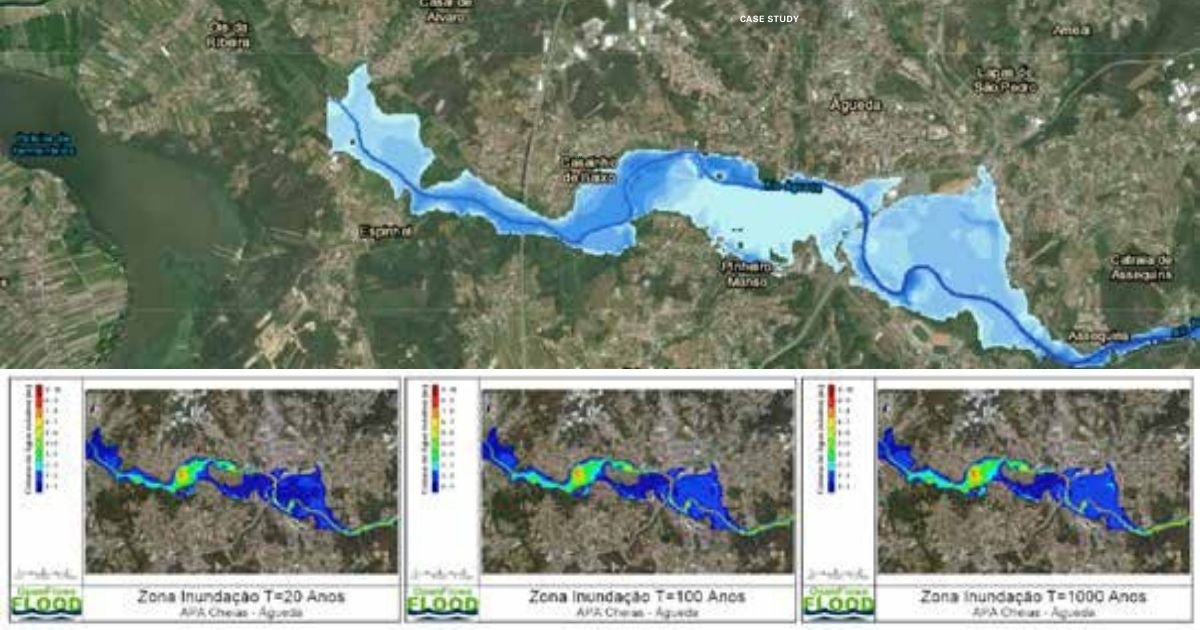
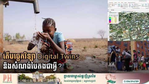
ការគ្រប់គ្រងប្រព័ន្ធទឹកបែបថ្មីដោយប្រើបច្ចេកវិទ្យា Digital Twin! សន្សំបានរាប់លានដុល្លារ! ក្រុមហ៊ុនបង្កើតកម្មវិធីសំណង់ឌីជីថលលំដាប់ពិភពលោក Bentley Systems ថ្មីៗបានបង្ហាញនូវបច្ចេកវិទ្យាថ្មីមួយដើម្បីជួយឱ្យការគ្រប់គ្រងហេដ្ឋារចនាសម្ព័ន្ធប្រព័ន្ធផ្គត់ផ្គងទឹក កាន់តែមានប្រសិទ្ធភាព និងពិសេសអាចសន្សំថវិកាបានរាប់លានដុល្លារ តាមរយៈការប្ដូរពីគំរូធារាសាស្ត្រ (Hydraulic Modeling) បែបធម្មតាទៅជាបច្ចេកវិទ្យា “Digital Twin” បែបរស់រវើក។ កម្មវិធី OpenFlows របស់ Bentley បច្ចុប្បន្ននេះគឺអាចភ្ជាប់ប្លង់មេបែប 2D ធម្មតាៗ ទៅនឹងទិន្នន័យថ្មី ហើយបង្កើតជាប្រព័ន្ធគ្រប់គ្រងប្រតិបត្តិការបែបជាក់ស្តែងពិតៗ ឬ Real-time ដែលជួយឱ្យស្ថាប័នផ្គត់ផ្គង់ទឹកអាចមើលឃើញពីតថភាពជាក់ស្តែងនៃប្រព័ន្ធទឹកទាំងមូល ពិសេសសម្រាប់ការពិនិត្យរកកំហូច។ អត្ថប្រយោជន៍នៃការផ្លាស់ប្តូរនេះ កំពុងជួយស្ថាប័នគ្រប់គ្រងទឹកទូទាំងសកលលោក។ តាមរយៈការប្រើប្រាស់កម្មវិធីនេះ ក្រុមហ៊ុនវិស្វកម្មនៅក្នុងប្រទេសឥណ្ឌា និងប្រេស៊ីល បានរាយការណ៍ថា ពួកគេអាចកាត់បន្ថយពេលវេលារចនាម៉ូដបានរហូតដល់ ៨០% និងសន្សំសំចៃថវិការាប់លានដុល្លារលើថ្លៃដើមហេដ្ឋារចនាសម្ព័ន្ធ។ លើសពីការសាងសង់ បច្ចេកវិទ្យានេះក៏ជួយឱ្យអ្នកប្រតិបត្តិការអាចបង្កើនប្រសិទ្ធភាពកាលវិភាគម៉ាស៊ីនបូមទឹក កាត់បន្ថយការប្រើប្រាស់ថាមពល និងឆ្លើយតបបានកាន់តែរហ័សចំពោះបញ្ហាការបែកបំពង់ទឹក។ តាមរយៈការបញ្ចូលទិន្នន័យ SCADA ជាក់ស្តែង ស្ថាប័នដូចជា DC Water បច្ចុប្បន្នអាចធ្វើការសម្រេចចិត្តបានត្រឹមត្រូវ និងភ្លាមៗ ដើម្បីធានាបាននូវគុណភាពទឹក និងភាពធន់នៃប្រព័ន្ធសម្រាប់ប្រជាជនរាប់លាននាក់។ នាពេលអនាគត Bentley […]
Bentley Systems Uses Digital Twins to Build a Greener Future
- 4 May 2026
Bentley Systems is using “digital twin” technology to make the world’s water and energy systems more sustainable. By creating virtual replicas of real-world infrastructure, engineers can test and improve how projects work before they are even built, saving massive amounts of energy and natural resources. As global water demand intensifies, Bentley is deploying hydraulic modeling […]

Digital Innovation Secures Water Future for 1.4 Million Families in Colombia
- 18 April 2026
Empresas Públicas de Medellín (EPM) of Colombia has successfully transformed the city’s water network, ensuring that 1.4 million families have access to reliable and affordable water through a digital modeling system. The centerpiece of this transformation is Bentley Systems’ OpenFlows Water software. Before adopting this technology, EPM engineers had to rely on fragmented spreadsheets and […]