 English
  ខ្មែរ
ខ្មែរ 

France Advances Massive Canal Project with Digital Engineering
- 11 July 2026
France is currently undertaking the construction of the Seine-Nord Europe Canal, a €7.3 billion project set to become the continent’s most ambitious waterway initiative in a century. Stretching 107 kilometers, the canal will provide France with direct freight access to major northern European ports like Rotterdam and Antwerp. To overcome the immense engineering challenges of […]

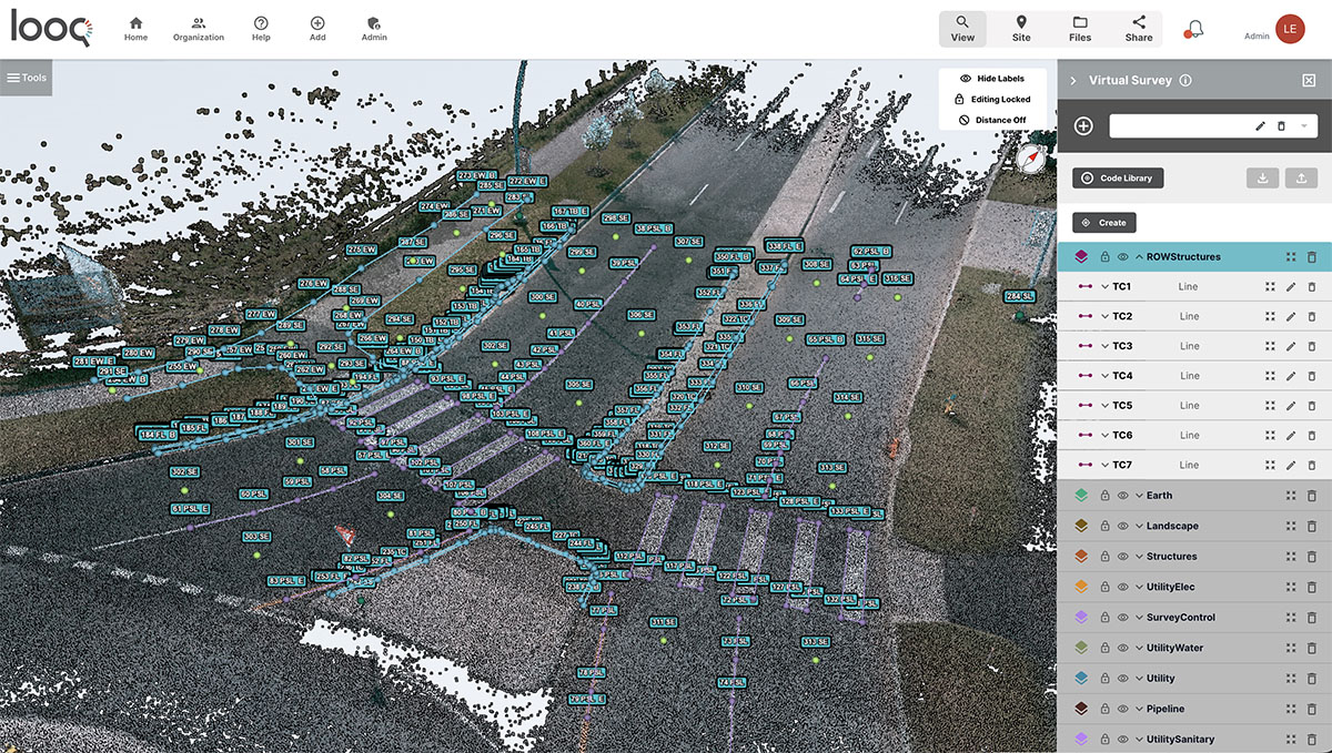
Infrastructure Leaders Overcome Data Silos with Unified Reality Modeling
- 10 July 2026
Infrastructure organizations are increasingly turning to Bentley Systems’ iTwin Capture suite to transform disjointed data into powerful, intelligent digital twins. Previously, project teams struggled with “data silos,” where incompatible formats from lidar, photogrammetry, and geospatial sensors remained isolated, preventing comprehensive site analysis. This manual, disconnected approach often led to slow, costly processes that hindered real-time […]

Interactive 3D Experience Brings 2026 World Cup Stadiums to Life
- 5 July 2026
Soccer fans can now explore the expansive geography of the 2026 FIFA World Cup through a new interactive 3D digital tour. Created by Bentley Systems, the experience utilizes the company’s Cesium geospatial platform to provide detailed digital replicas of all 16 host stadiums across Mexico, Canada, and the United States. Users can fly between host […]

Bentley Systems Declares Q2 2026 Dividend Amidst Wave of AI-Driven Infrastructure Innovation
- 4 July 2026
Bentley Systems, a global leader in infrastructure engineering software, has recently declared a cash dividend of $0.07 per share for the second quarter of 2026. This financial milestone comes during a period of significant momentum for the company, as Bentley accelerates its efforts to modernize the global infrastructure landscape through advancements in Artificial Intelligence (AI) […]

New York City Fortifies Coastline Against Future Superstorms
- 2 July 2026
In the years following the devastating flooding caused by Hurricane Sandy in 2012, New York City has undertaken a massive engineering effort to transform its vulnerable coastline into a resilient fortress. Central to this transformation is the East Side Coastal Resiliency project, which utilizes advanced infrastructure to protect critical utilities like Con Edison’s East River […]

Future of Construction Symposium Spotlights Digital Innovation in Infrastructure
- 29 June 2026
The recent Future of Construction symposium at ETH Zurich, sponsored by Bentley Systems, highlighted how cutting-edge digital tools are fundamentally transforming the design and construction landscape. The event brought together industry leaders and academics to explore the integration of robotics and artificial intelligence in building complex, modern infrastructure. Bentley Systems played a central role in […]