 English
  ខ្មែរ
ខ្មែរ 


Bentley Acquires Talon Aerolytics, and Pointivo Technology for Asset Analytics Leadership
- 14 June 2026
Infrastructure engineering software company Bentley Systems has announced the acquisition of Talon Aerolytics and the technology of Pointivo. The strategic moves significantly expand Bentley’s Asset Analytics portfolio, reinforcing its capabilities in leveraging digital twins and AI to optimize infrastructure performance. The newly integrated software solutions specifically target telecommunications and electric utilities, driving global 5G deployment […]

Western Cape Partners with Bentley Systems to Modernize 5,000 Kilometers of Roads
- 11 June 2026
The Western Cape Department of Infrastructure has partnered with Bentley Systems to modernize its road safety and maintenance across 5,000 kilometers of strategic roadways. This landmark initiative marks the first deployment of Bentley’s AI-powered Blyncsy technology on the African continent. Faced with limited budgets and severe weather events, the province is utilizing Blyncsy to shift […]

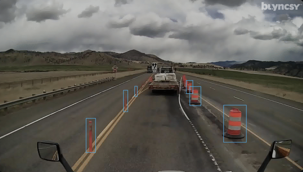
ALDOT Integrates Bentley’s AI to Refine Performance-Based Highway Budgeting
- 18 February 2026
Alabama Utilizes Bentley Tech to strengthen data-driven maintenance planning The Alabama Department of Transportation (ALDOT) is enhancing its long-standing performance-based budgeting model by integrating Blyncsy, an AI-powered solution from Bentley Systems. For more than 15 years, ALDOT has led the way in using data to drive financial decisions, but the manual collection of condition data […]
Hawaii Enlists Citizen Drivers and AI to Revolutionize Road Maintenance
- 14 January 2026
The Hawai‘i Department of Transportation (HDOT) has launched a pioneering program, “Eyes on the Road,” using artificial intelligence to transform how the state identifies and repairs road hazards. By turning everyday commuters into data collectors, the state aims to stay ahead of the relentless wear and tear caused by Hawai‘i’s unique volcanic and tropical environment. […]

Digital Reality Check: How 3D Geospatial Tech is Minimizing Costly Mistakes in Global Construction
- 14 November 2025
In the high-stakes world of construction, where a single wrong decision can cost millions, infrastructure developers are increasingly turning to 3D geospatial technology to test and visualize their choices before breaking ground. Bentley Systems, the infrastructure engineering software giant, is spearheading this shift by integrating the advanced capabilities of its recent acquisition, Cesium, into the […]

Global Partnership Unleashes AI to Combat Climate Change, Disasters
- 12 October 2025
At a recent event during London Climate Action Week, Google and its partners unveiled powerful new applications of AI aimed at boosting climate resilience, cutting global warming, and enhancing urban infrastructure. The core message from the “Google AI for the Planet” event was clear: collaboration between technology, academia, and industry is “absolutely essential” to tackle […]